RISING temperatures over Antarctica have been a major contributing factor to recent volatile weather along the East Coast, according to new information from the Bureau of Meteorology (BOM).
A “sudden stratospheric warming” (SSW) is to blame.
This is a documented weather scenario in which air temperatures high above the South Pole rise by 30 degrees or more in the space of a week.
This latest SSW began in late September.
According to the BOM, they are relatively rare in the Southern Hemisphere, but have the potential to disrupt weather patterns across the Australian continent for months.
Only two major SSWs have been recorded in the last 60 years: in 2002 and 2019.
Both those years immediately preceded devastating bushfire events, however they came on the tail of prolonged drought conditions and El Nino weather patterns, whereas 2025 has been exceedingly wet and a mild La Nina is on the horizon for the months ahead.
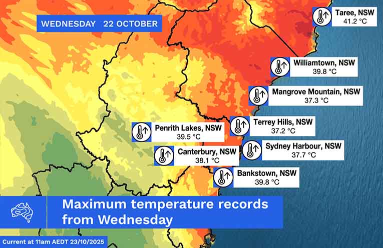
Last Wednesday, 22 October, was a stifling 40-degree scorcher along the coast.
BOM meteorologist Angus Hines described it as a “bubble of heat, moving over central Australia, coming east from northwestern NSW”.
“This hot wind blew from the desert towards the coast… causing temperatures to soar across the Illawarra, Sydney, the Central Coast, the Hunter and the Mid North Coast.”
BOM information shows that new records have been set for October.
Some overnight temperatures, however, dropped precipitously to around 15 degrees, confounding many who had started the evening dressed for Summer only to wake in the middle of a chilly wintry night.
When an SSE does occur over the South Pole, a meteorologically complex chain reaction ensues, which can eventuate in westerly winds hitting southern Australia, bringing warm, dry weather to the east.
“Cold fronts embedded in the westerlies also increase in number, leading to frequent bursts of strong winds and high fire danger days, and potentially an enhanced contrast in weather between the country’s east and south coast,” said ABC Meteorologist Tom Saunders.
So far, in October alone, there have been a handful of “Extreme” fire danger days, which were flagged in forecasts of spiking temperatures, and followed relatively mild weather in the mid-20s.
BOM Meteorologist Felicity Gamble has pointed to a similar case of a weak, relatively unknown SSW event in October 1988 that had weather patterns similar to 2025.
It may offer clues to what to expect for the rest of this year.
“November’s rain prospects have also eased in recent model updates, and research suggests the dominance of warmer and drier weather from an SSW can linger until January,” said Ms Gamble.
The coming clouds have one silver lining, at least, being “a suppression of super-cold polar stratospheric ice clouds, which are key to the chemical process that destroys ozone.”
By Thomas O’KEEFE
